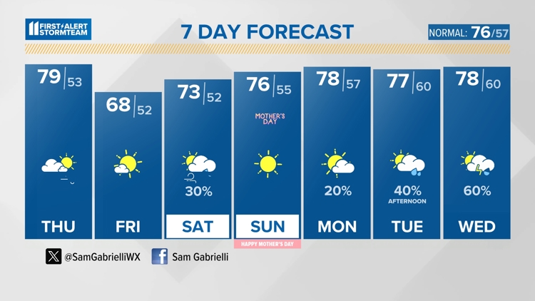
Weather Headlines
- Drying trend to end the week | First Alert StormTeam Forecast
- Hoosiers surveying damage from EF-0 tornado that hit southern Indiana
- Tornado watch issued for parts of Kentucky and Indiana | All weather alerts here
- LIVE RADAR | Track severe storms in the Louisville area
- After deadly floods, southern Brazil deals with a new crisis: access to basic goods
10-Day Forecast
Thu
May 09
79
53
10%
13
MPH
W
Mix of sun and clouds. Highs in the low 80s and lows in the mid 50s.
55%
High
6:36 AM
8:42 PM
Fri
May 10
68
52
0%
13
MPH
SW
Times of sun and clouds. Highs in the upper 60s and lows in the low 50s.
57%
Very High
6:35 AM
8:43 PM
Sat
May 11
73
52
30%
13
MPH
SW
Times of sun and clouds. Highs in the mid 70s and lows in the low 50s.
58%
Very High
6:34 AM
8:44 PM
Sun
May 12
76
55
10%
13
MPH
WSW
Abundant sunshine. Highs in the upper 70s and lows in the mid 50s.
56%
Very High
6:33 AM
8:44 PM
Mon
May 13
78
57
20%
11
MPH
WSW
Showers possible in the afternoon. Highs in the upper 70s and lows in the low 60s.
54%
High
6:33 AM
8:45 PM
Tue
May 14
77
60
40%
11
MPH
SSW
Showers and thunderstorms. Highs in the low 70s and lows in the low 60s.
54%
Moderate
6:32 AM
8:46 PM
Wed
May 15
78
60
60%
12
MPH
WSW
Scattered thunderstorms possible. Highs in the mid 70s and lows in the upper 50s.
57%
High
6:31 AM
8:47 PM
Thu
May 16
78
60
36%
11
MPH
SW
Scattered thunderstorms possible. Highs in the upper 70s and lows in the low 60s.
62%
High
6:30 AM
8:48 PM
Fri
May 17
81
64
58%
11
MPH
SW
Chance of showers. Highs in the mid 70s and lows in the low 60s.
61%
Very High
6:29 AM
8:49 PM
Sat
May 18
83
65
37%
11
MPH
SSW
Plenty of sun. Highs in the low 80s and lows in the low 60s.
60%
Very High
6:28 AM
8:50 PM
Hourly Forecast
9 AM
Thu
70°
31%
11
MPH
WSW
10 AM
Thu
70°
30%
12
MPH
WSW
11 AM
Thu
71°
23%
13
MPH
WSW
12 PM
Thu
73°
16%
13
MPH
WSW
1 PM
Thu
75°
15%
15
MPH
W
2 PM
Thu
76°
15%
15
MPH
W
3 PM
Thu
78°
15%
16
MPH
W
4 PM
Thu
79°
15%
17
MPH
W
5 PM
Thu
78°
22%
19
MPH
W
6 PM
Thu
75°
24%
18
MPH
WNW
7 PM
Thu
72°
21%
16
MPH
WNW
8 PM
Thu
68°
9%
14
MPH
NW